In the Outer Hebrides (a group of islands near Scotland), there is a small island chain known as the Flannan Isles. There are two main islands in this chain; Eilean Mòr and Eilean Taighe, and from 1895-1899, construction on a lighthouse took place on Eilean Mòr. No permanent residents have lived on the Isles since the lighthouse became automated in 1971. Overall, the island chain would be quite unremarkable if it hadn’t been for the mysterious and still-unexplained event that occurred only one year after construction on the lighthouse was finished.

Location of the Flannan Isles
After it was built, the lighthouse was operated by three men; Thomas Marshall, James Ducat and Donald Macarthur. Late in 1900, crew members of a passing ship noticed that something was amiss. The light was not on, which was especially strange given the poor weather conditions. They reported it to the authorities when they arrived at their destination, and a team was sent to the Flannan Isles to investigate. The team immediately realized that something was wrong when no one was there to greet them. All three of the lighthouse keepers had vanished.

The lighthouse on Eilean Mòr. Credit: Marc Calhoun (geograph.org.uk)
The only other seemingly out-of-place thing was a chair that had been overturned in the lighthouse kitchen. Further investigation of the lighthouse and the island showed extensive storm damage to the west landing on the island, so at first, investigators thought that the men may have been washed away in the storm. However, they had kept logs of their activity right up until the morning that they disappeared (15th December), and the storm damage had apparently occurred sometime before this date.
The men were never seen again, and no bodies ever turned up.
Naturally, this strange occurrence led to wild speculation about what may have happened to the three men. Some alleged that one of the men had murdered the others, and then drowned himself out of guilt. It was also claimed that an enormous sea monster had taken them, while others blamed their disappearance on abduction by foreign spies. Some people also claimed that it was the work of malevolent ghosts, and modern theories mention alien abduction.

Some think that a giant sea monster took the men
After an official investigation, the Northern Lighthouse Board came to the conclusion that the men must have been swept away by a freak wave while they were attempting to secure a box of equipment on the west landing, which was damaged in the previous storm (as recorded in their logs).
A more recent theory claims that a kind of geological formation known as ‘geos’ may have been to blame for the disappearance. A geo is an inlet or cleft in the face of a cliff, caused by wave erosion, and sea caves can form at their heads.
Eilean Mòr has many geos along its coastline, and the west landing of the island is actually situated in a geo. This geo terminates in a sea cave. In stormy weather, water could rush into the cave and explode out again. The theory holds that two of the men may have been securing the box on the west landing, while the other kept watch from the lighthouse. Noticing approaching waves, the watcher raced down to warn his colleagues of the impending danger, knocking a chair over in his haste to get out. Upon getting down to the west landing to warn them, he could have been washed out to sea by the water that exploded out of the sea cave, along with his two colleagues.
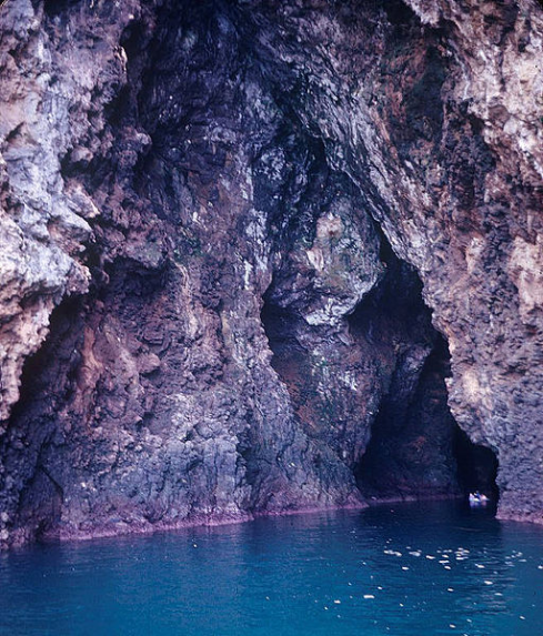
An example of a sea cave
A very similar theory claims that one man may have been washed out to sea, and the other ran back to the lighthouse to get help. Upon attempting to rescue the man, both remaining men were washed out to sea by a second freak wave.
So, was the disappearance simply a combination of poor weather and bad luck, or did something far more sinister occur? We do know that when the men disappeared, the weather conditions were very poor, so I think that either one of the freak wave/geo theories would make sense. However, we will probably never know exactly what happened, so the mystery remains open to speculation.
Tags: Architecture, Building Types, Flannan Isles, freak wave, geo, geological formation, ghosts, Lighthouse, Northern Lighthouse Board, Outer Hebrides, paranormal, Scotland, sea cave, UFO, unexplained, Weather, weird


You must be logged in to post a comment.