Tag Archives: Archaeology

The Ice Mummies

17 Apr

The Inca Empire was the largest empire in the Americas before the arrival of Columbus. Within Incan culture, human sacrifices were sometimes carried out as offerings to the gods. Child sacrifices were often made in times of famine or before/after important events. The children were taken up to the tops of mountains and killed, or sometimes left to die of exposure (the mountain tops were freezing). This practice was known as ‘capacocha’, and early Spanish settlers mentioned it in their writings. In recent times, preserved remains of some of these children have actually been found by archaeologists. The remains of a child known as ‘Mummy Juanita’ is an example of one of these sacrificed children.

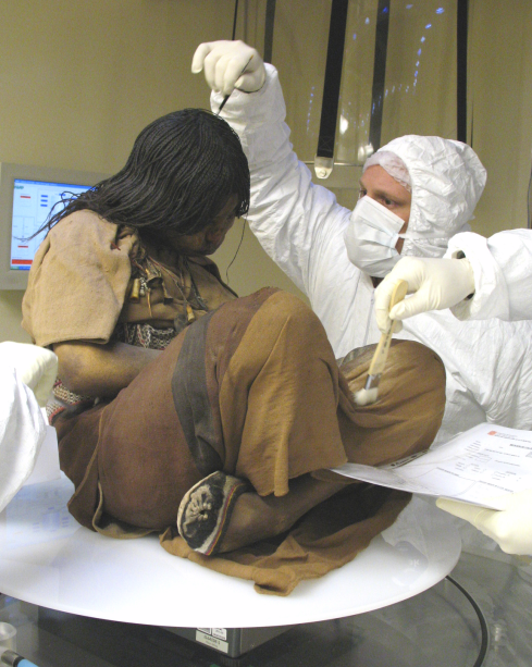
Mummy Juanita's frozen body

Mummy Juanita’s frozen body

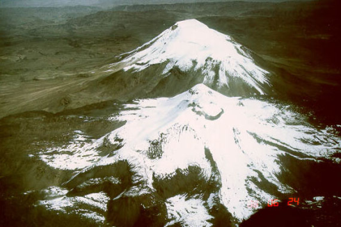
Mummy Juanita was found wrapped in a tapestry by archaeologist Johan Reinhard and his climbing partner in 1995, on Mount Ampato; a dormant stratovolcano in southern Peru. She was around 11-15 years old at time of death, and is thought to have been killed between the years of 1450-1480. Her body was frozen, which led to mummification. Later, two other well-preserved ‘ice mummies’ were found in close proximity to where Mummy Juanita was found. All had been killed by a blow to the head.

Mt. Amparo

Mt. Ampato

Location of Mt. Amparo in Peru

Location of Mt. Ampato in Peru

Because Mummy Juanita’s body was mummified, her internal organs were so well-preserved that it was possible for scientists to figure out what her last meal had been, even though she died over 500 years ago. She had eaten a meal of vegetables. It was also found that she had suffered from a lung infection shortly before her death. Her skin, hair, clothing and nails were also well-preserved. The tapestry that she had been wrapped in also contained many other Incan offerings; bowls, pins and figurines.

mummyjuanita3

Mummy Juanita’s face

A similar case was found on Llullaillaco, a mountain on the border of Chile and Argentina. Three frozen bodies were found in 1999 by Reinhard and fellow archaeologist, Constanza Ceruti. One of these is known as ‘la doncella’ (the maiden), and her body is amazingly preserved. Here’s some pictures of her:

mummyjuanita

La doncella

mummyjuanita1

La doncella was around 15 when she died. She was taken to the top of the mountain and left to die of exposure after being drugged with coca leaves and a type of maize beer. The other two mummies found with her were a young boy and a young girl. The boy was tied up, and died from strangulation, and the young girl was hit by lightning after her death. From testing the hair of the mummies, scientists could determine the diet that the children had lived on, and it was found that the children were fed a rich diet to ‘fatten them up’ before being sacrificed.

While the circumstances of these deaths are sad, these finds have allowed scientists a rare glimpse into the past.

To learn more on this, watch this documentary:

Petra – The Rose-Red City

11 Apr

In the country of Jordan, one of the ancient world’s most beautiful cities is still visible today. The entire city, known as Petra, was carved into the side of a cliff-face, and it has been nicknamed the ‘rose-red city’. This is because most of the rock that it was carved into is a light red color. The city is also famous for its evidence of an ancient water management system.

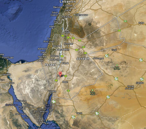
Location of Petra in Jordan

Location of Petra in Jordan

Here’s some photos of Petra:

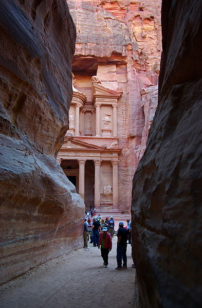
Al Khazneh - 'The Treasury'. Credit: Berthold Werner

Al Khazneh – ‘The Treasury’. Credit: Berthold Werner

Al Dier - 'The Monastery'. Credit: Dennis Jarvis (http://www.flickr.com/photos/archer10/2217568198/)

Al Dier – ‘The Monastery’. Credit: Dennis Jarvis (http://www.flickr.com/photos/archer10/2217568198/)

Credit: Berthold Werner

Credit: Berthold Werner

Close-up of the detail on Al Khazneh. Credit: Bernard Gagnon

Close-up of the detail on Al Khazneh. Credit: Bernard Gagnon

So, who built it?

Petra was built around 2000 years ago to serve as a capital city for the Nabataeans. The Nabataeans were an ancient Arabic people, and they established trade ties with many other groups at the time. Later, during Roman times, Petra was considered to be the capital of the Roman-Arabian world. During this period, the Petra Roman Road was constructed. This was the main entrance to the city, and featured enormous gates.

The Roman gates leading up to Petra. Credit: David Bjorgen

The Roman gates leading up to Petra. Credit: David Bjorgen

Unfortunately, during the period of Roman rule, Petra rapidly declined. In 363 AD, an earthquake destroyed a large proportion of the city, and it eventually fell into ruins. ‘Rediscovered’ by the Western world in 1812, it has been a popular Jordanian tourist destination ever since. It has also been classified as a World Heritage site, and it is quite vulnerable due to erosion/weathering and tourist damage. I hope that it can be preserved for future generations to enjoy.

To learn more about this amazing site, visit: http://whc.unesco.org/en/list/326

Gigantopithecus

6 Apr

From as long ago as 9 million years, all the way up to only 100,000 years ago, an enormous genus of ape roamed around the areas now known as China, India and Vietnam. It’s also possible that they co-existed with early humans. The first species of this genus to be discovered was Gigantopithecus blacki, and was actually found by chance. In 1935, archaeologist Ralph von Koenigswald found some fossilised teeth in a Chinese medicine shop, and realized that they were from an unknown species. The teeth were usually ground up and used as part of traditional medicines.

While a full skeleton for the giant ape hasn’t yet been found, archaeologists can infer their size from dental remains that have been found. So, exactly how big were these apes? Scientists believe that the males could grow up to 10 feet tall, and weighed as much as 1,200 lb. Females were quite a lot smaller, due to sexual dimorphism. Like many other apes, they were most likely quadrupeds (this means that they moved around on four legs).

Cast of G. blacki's lower mandible. Credit: Mark A. Wilson (http://commons.wikimedia.org/wiki/User:Wilson44691)

Cast of G. blacki’s lower mandible. Credit: Mark A. Wilson (http://commons.wikimedia.org/wiki/User:Wilson44691)

This is what the gigantopithecus may have looked like. Source: http://img102.fansshare.com/pic131/w/non-celebrity/369/13006_gigantopithecus_std.jpg?rnd=2700

This is what the gigantopithecus may have looked like. Source: http://img102.fansshare.com/pic131/w/non-celebrity/369/13006_gigantopithecus_std.jpg?rnd=2700

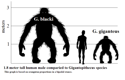
G. blacki is thought to have lived in Southeast Asia, and dental analysis shows that it probably lived on bamboo and other plants. Furthermore, since the initial discovery of G. blacki, two more extinct gigantopithecus species have been found; Gigantopithecus giganteus and Gigantopithecus bilaspurensis. G. bilaspurensis lived in India, and G. giganteus appears to have lived in northern India and China. Despite its name, G. giganteus was actually about half the size of G. blacki.

Size comparison of gigantopithecus and human. Credit: http://en.wikipedia.org/wiki/User:Discott

Size comparison of gigantopithecus and human. Credit: http://en.wikipedia.org/wiki/User:Discott

Some conspiracy theorists believe that the gigantopithecus apes may still exist today, and are the reason why legends of Bigfoot, yetis and the like exist throughout the world. Unfortunately for proponents of this theory, there is no evidence that this is true. In fact, humans may have actually led to the decline and later extinction of the species, by using valuable resources that the apes needed to survive.

To read more on the subject, visit: http://www.uiowa.edu/~bioanth/giganto.html

Leptis Magna

5 Apr

All throughout Europe, there are many beautiful ancient Roman ruins, but there are equally-magnificent and lesser-known ruins on other continents too. A good example of this is Leptis Magna. Leptis Magna is the remnants of a once-great Roman port city, and is considered to be one of the most impressive and unspoiled Roman ruins in the world.

The city ruins are near the coast in the African country of Libya, around 80 miles from its capital, Tripoli.

Location of Leptis Magna in Libya

Location of Leptis Magna in Libya

Here’s some pictures of the city:

Leptis Magna's arch of Septimius Severus. Credit: David Gunn

Leptis Magna’s arch of Septimius Severus. Credit: David Gunn

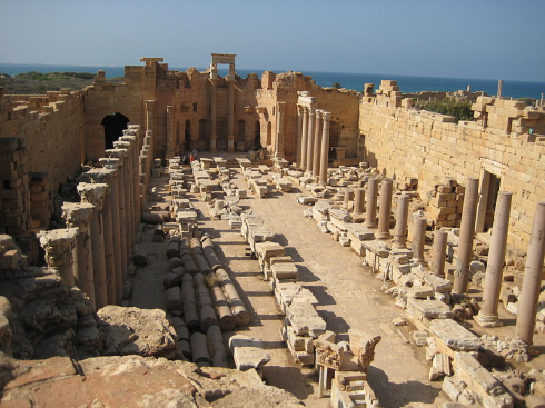
The basilica of Septimius Severus. Credit: Sasha Coachman

The basilica of Septimius Severus. Credit: Sasha Coachman

Close-up of part of the basilica of Septimius Severus. Credit: Sasha Coachman

Close-up of part of the basilica of Septimius Severus. Credit: Sasha Coachman

The city was founded by the Phoenicians around 3000 years ago, and was originally called Lpqy. During the reign of the Roman Emperor Tiberius, it became a thriving trade city. Then, from the year 193 onwards, it became one of Roman Africa’s most prominent cities. This was because the Roman Emperor at that time, Septimius Severus, was actually born in Leptis Magna, so he naturally favoured his home-city over others. Severus enlarged the city, and as a result Leptis Magna contains many Roman-inspired buildings; forums, a theatre, public baths, marketplaces and monuments, to name a few.

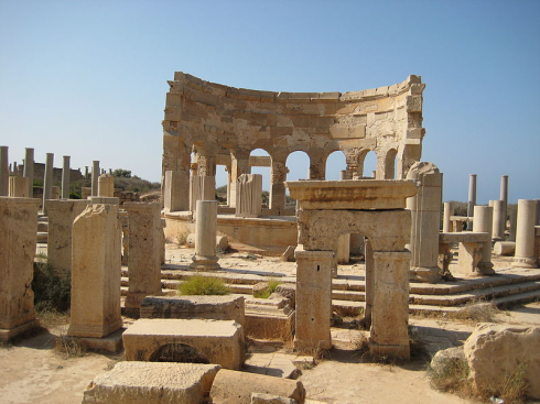
The theatre. Credit:(http://commons.wikimedia.org/wiki/User:Man)

The theatre at Leptis Magna. Credit:(http://commons.wikimedia.org/wiki/User:Man)

Another view of the theatre. Credit:(http://commons.wikimedia.org/wiki/User:Man)

Another view of the theatre. Credit:(http://commons.wikimedia.org/wiki/User:Man)

An entrance to the theatre. Credit: Sasha Coachman

An entrance to the theatre. Credit: Sasha Coachman

View of the marketplace in Leptis Magna. Credit: Sasha Coachman

View of the marketplace in Leptis Magna. Credit: Sasha Coachman

Public baths in Leptis Magna. Credit:(http://commons.wikimedia.org/wiki/User:Man)

Public baths in Leptis Magna. Credit:(http://commons.wikimedia.org/wiki/User:Man)

Eventually, the city was ransacked by the Vandals, and later by the Berbers. Byzantine Empire general Flavius Belisarius tried to re-establish it as a provincial Byzantine capital, but the city didn’t recover from the destruction that previous raiders had caused. By the year 650 AD, the city was mostly abandoned.

Libya isn’t the easiest country to visit due to its political instability, but Leptis Magna would certainly be a wonderful place to see. Archaeologists have still not finished excavating the ruins, so it will also be interesting to see what else ends up being discovered in the future.

Doggerland

31 Mar

It’s quite hard to imagine that only a few thousand years ago, there were lands on which people lived that have now completely disappeared into the ocean. But, this is exactly what happened to the area known as ‘Doggerland’.

Up until around 8500-8200 years ago, Doggerland was a large stretch of dry land that linked the European mainland to where the British Isles are today. Here’s a picture to show where it was, compared with what the area looks like today:

This is where Doggerland used to be in Europe. Credit: Max Naylor

This is where Doggerland used to be in Europe. Credit: Max Naylor

The same area today, minus Doggerland

The same area today, minus Doggerland

So, what happened to Doggerland, and how do we know about it?

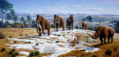
Archaeologists first started to think that the area may have originally been above sea level in the early 1900’s, when fishing boats in the area would occasionally dredge up the remains of animals that had lived in Europe in prehistoric times, including mammoths and lions (yes, Europe used to have lions!). Plant remains were also brought up and studied by paleobiologists, who found them to be peat from when the land was above sea level and mostly tundra.

To add further interest, prehistoric tools and weapons used by ancient peoples were also found. Archaeologists now believe that Doggerland was occupied by humans during the Mesolithic period (this period started around 10,000 years ago), up until it started to disappear underwater. In fact, some think that it may have been one of the richest hunting and fishing environments available to European humans at the time.

Whilst surveying the area for petroleum, oil-company geologists produced seismic surveys of the land beneath the waves, and in 2012, the Royal Academy of London presented the results of the surveys along with all the artefacts that have been found so far. The seismic surveys allow researchers to see what the land looked like while it was still above sea level, and even Doggerland’s ancient river systems have been mapped in 3D. The largest of these rivers is known as the ‘Shotton River’.

In regards to the disappearance of Doggerland, researchers believe that at the end of the last glacial period, sea levels began to rise dramatically as the climate warmed up. Due to this, Doggerland was eventually submerged under the North Sea, and the British Isles were separated from the European mainland. This probably all happened around 8500 years ago.

Another recent theory claims that after already losing some land to rising sea levels, Doggerland may have become completely submerged as the result of a tsunami that hit the area 8200 years ago. This tsunami was caused by an event known as the ‘Storegga Slide’. It is named this because the event was a massive underwater landslide, occurring off the coast of Norway. The resulting tsunami would have been devastating to Mesolithic people who still lived on Dogger Bank, and after this event, British Mesolithic populations would have been totally separated from the rest.

The yellow numbers represent the height (in meters) of the tsunami waves from the Storegga Slide. Credit: Lamiot

The yellow numbers represent the height (in meters) of the tsunami waves from the Storegga Slide. Credit: Lamiot

One part of Doggerland actually remained for quite a while longer. An island known as ‘Dogger Bank’ emerged when the rest went underwater. Dogger Bank was an upland hill area of the original Doggerland, so the sea levels didn’t rise high enough to cover it. Eventually, however, Dogger Bank also disappeared into the ocean, and this probably happened around 7000 years ago. Here is a map that shows us where Dogger Bank is now:

The red line marks where Dogger Bank used to be. Credit: NASA

The red line marks where Dogger Bank used to be. Credit: NASA

It is fascinating to think that once-populated lands are now totally underwater. Geologists and archaeologists really have the most interesting jobs sometimes!

Bog Bodies

28 Mar

Depending on certain variables, human decomposition is generally a very short process, and a dead body buried underground will normally be completely skeletonized in a maximum period of 50 years. If left out in the open, a body will decompose much faster than this. However, the mummified remains of bodies found in peat bogs, known as ‘bog bodies’, can be up to thousands of years old and almost perfectly preserved.

Tollund Man - Found in Denmark and found to be around 2600 years old. Credit: Sven Rosborn

Tollund Man – Found in Denmark and dated to around 2400 years ago. Credit: Sven Rosborn

Grauballe Man - Found in Denmark and dated to 2300 years ago. Credit: Malene Thyssen

Grauballe Man – Found in Denmark and dated to 2300 years ago. Credit: Malene Thyssen

Rendswühren Man - Found in Germany and dated to around 1900 years old

Rendswühren Man – Found in Germany and dated to around 1900 years old

Brammer Man - Found in Germany and dated to around 500 years ago. Note the still visible beard on his face.

Brammer Man – Found in Germany and dated to around 500 years ago. Note the still-visible beard on his face.

Peat bogs are most prevalent in cold, temperate areas of the Northern Hemisphere (it is possible for them to occur in the Southern Hemisphere, but they are much smaller and less common), and thus, all the bog bodies located so far have been in Northern Europe and North America. Not all are well-preserved, but many still have intact hair, skin and internal organs. So, how is this possible? And, how did the bodies get there in the first place?

Peat bog - Credit to Boréal

Peat bog. Credit: Boréal

The water in peat bogs is cold, acidic, and lacks oxygen, and combined, these factors lead to amazing tissue preservation. Also, tannin (a compound present in tea – this is the stuff that can stain your tea-cups) in the bogs leads to the darker appearance of the skin, and has anti-bacterial properties that aid in the preservation. Unfortunately, the acid in the bog water often destroys the bones, as it dissolves the calcium phosphate in them, leaving only the tissue and hair preserved.

Because of the good soft-tissue preservation, the stomach contents of the bodies can be analysed in some cases, which tells us something about the diets of people during whichever period they lived in. In cases where bones have been preserved, archaeologists can tell what kinds of activities the person engaged in, and even if they were right-handed or left-handed! Also, forensic techniques have been applied to some of the bodies in order to reconstruct their appearances. Here’s some examples:

Reconstruction of Lindow Man's face - Credit: www.culture24.org.uk

Reconstruction of Lindow Man’s face. Credit: http://www.culture24.org.uk

Reconstructed face of the Girl from Uchter Moor - Credit to AxelHH

Reconstructed face of the Girl from Uchter Moor. Credit: AxelHH

The bodies that have been recovered from peat bogs cover a very wide time span, with some dated from 10,000 years ago and others all the way up to World War II. It seems that some of the bodies belonged to unlucky individuals who simply fell in, but many others appear to have died violently, after which they were thrown into the bogs. This may have been as punishment for a crime, or, perhaps it was human sacrifice. The majority of the violently-killed bodies have been dated to the Iron Age (this began around 3000 years ago, and lasted about 500 years), so some archaeologists believe that Iron Age groups may have had this means of execution or ritual sacrifice as a cultural tradition.

Overall, the bog bodies are not only interesting, but very useful to historians, archaeologists, and anthropologists, as they yield so much useful information in regards to past peoples who lived around the bogs. For more reading on the topic, check out

http://archive.archaeology.org/online/features/bog/

http://ngm.nationalgeographic.com/2007/09/bog-bodies/bog-bodies-text

The Antikythera Mechanism

24 Mar

The Antikythera shipwreck, discovered off the Greek coast by divers in 1900, has yielded several artefacts that have been dated back to just over 2000 years ago, including coins and statues. The most important find, however, was something that is now known as the ‘Antikythera mechanism’.

antikythera1

The mechanism as it appears today

This mechanism has the honor of being known as the world’s most ancient analog computer. Archaeologists and other researchers examining the mechanism have been astounded, claiming that technology didn’t even begin to approach the same level of complexity until 14th century AD Europe. That’s an enormous gap in time! But, what was it actually used for?

antikythera2

Computer-generated model of what the mechanism’s front side would look like today

Scientists have found that it was used for more than one purpose, and research is still being conducted today to find out any other uses. Basically, it was used as an astronomical clock; it could determine the relative positions of the sun, moon, stars and even some planets, and also predict things like eclipses. The mechanism showed the sun revolving around the Earth on a 24-hour dial, although as we know now, it is the other way around.

It was also apparently used as a calendar, but not just your typical one-year calendar; it showed four-year cycles, each divided into one year each. This is thought to have represented the Olympic Games of the time, which occurred in two and four year cycles. On top of this, it also tracked something known as the Metonic calendar, which is a period of 19 years used by ancient astronomers for astronomical and calendar studies.

Overall, the Antikythera mechanism is definitely high on my list of the most fascinating archaeological discoveries of the ancient Greek world. Many people seem to think that complex technologies couldn’t possibly have been used by ancient peoples, but this artefact would certainly prove them wrong.

For a more in-depth discussion of the mechanism, check out the articles in Nature science journal.